Seamus Cullen’s Personal Web Site
Featuring Local History from North Kildare
The Pale
Published in Oughterany, 1993
The Pale had its origin in the 15th century with the construction of a boundary enclosing an area surrounding Dublin. This boundary could be described as England’s version of Hadrian’s Wall. In 1453 the counties of Kildare, Dublin, Meath and Louth were identified as ‘the four obedient counties’ and the largest section of the country that was regarded as true English land. Similar areas also existed in districts surrounding isolated towns and also an area of the south-east which later became known as the Wexford Pale. The word Pale comes from the Latin Palus—a stake. The name Pale came from an earthen fortification built at that time around Calais, England’s last French possession.

Map showing the Pale boundary between Kilcock and Clane
Map by S. Cullen
The English colony in Ireland had shrunk considerably throughout the 14th and 15th centuries. By the 15th century the Norman colonists, brought to the north west area of Kildare in the period after the Norman invasion, had by in large fused with the native Irish who had remained as serfs and to a lesser extent as tenants. The Irish language had not gone out of use in the great boglands to the west where the population was of pure Gaelic origin. The colonists in this area had abandoned their language Norman-French, and now spoke Irish. The area between the Irish held areas and the English colony was called the marches and adhered to laws called ‘March Law’. These laws were a mixture of Common Law (English Law) and Brehon Law. The Anglo-Norman or English colonists at this time, who lived inside the Pale, spoke English and adhered to English laws and customs.
One of the most alarming developments at the time was the continued spread of the Irish customs and the Gaelic Brehon laws into North Kildare. An earlier Pale type line of defence had been constructed locally in North Kildare, extending from North to South. This defence system consisted of three Motte and Bailey castles at Cloncurry, Hortland and Mainham. Its purpose was to safe guard the area from raids by native Irish including the O’Connors who had established a safe haven in the boglands. By the 14th century the Motte and Bailey Castles had been replaced by strong stone castles at Cloncurry, Donadea and Clongoweswood. It is known that a strong stone Castle were in existence at Donadea in the mid 14th century when Sir John Birmingham was lord of the area and this had replaced Hotland as the main fortification for the area. However, by the 1490s the area found itself in the ‘March lands’ just outside the Pale. Mainham which had suffered greatly from plagues and attacks by the O’Connor’s also found itself replaced as the main fortification by the Castle at Clongoweswood.
The ordinary inhabitants outside the Pale lived in clahans and villages. A clahan is a group of dwelling houses and out houses clustered together in a small area. Sometimes they belonged to people who were related or who were of the same family. The name Bally which appears in numerous townlands may have come from small clahan communities. The dwellings were one and two roomed mud walled cabins which had a hearth in the middle of the floor and a hole in the roof to let the smoke out. The dwellings of the ordinary people inside the Pale were more modern at this time and chimneys were becoming fashionable.
The most powerful figure in the country at this time was the Viceroy Garret Mór FitzGerald the Earl of Kildare. As Viceroy he controlled Dublin City and ‘the four obedient counties’. Within this area he held extensive lands mainly in County Kildare and also exerted substantial influence throughout the country. However, he was a supporter of the Yorkest pretenders to the throne and the King, Henry VII, was from the Lancastrian party. Between 1487 and 1491 Garret Mór was implicated in two plots to replace Henry VII by Yorkest pretenders. The King could not allow the continuance of the threat that his Viceroy presented. In 1494 Garret Mór was replaced as Viceroy by Sir Edward Poynings. An uneasy peace that had existed between the native Irish and the Crown broke down and a campaign of raids against the ‘Crown lands’ took place. One of the most prominent Chieftains involved was Brian O’Connor of Offaly, who was one of Garret Mór’s allies, and he carried off great numbers of cattle and plunder. The raiders used the bogs and wastelands as hideouts and the section of the Bog of Allen at Timahoe which was the nearest bog to the Pale, was probably used in this manner.
The new Viceroy, Poynings took immediate action and summoned a Parliament to meet at Drogheda. One of the Acts of this Parliament, provided for the security of the four obedient counties by the erection of a Pale boundary. The limits of the Pale had been defined by an earlier Parliamentary Act of 1788, but the 1494 Parliament provided for a rampart to be built. It was constructed as a line of defence around Dublin to protect the Pale dwellers from attack and plunder from English rebels and Irish enemies, and also to prevent cattle being driven from the Pale to Irish areas. The boundary consisted of a double ditch with a six foot high earthen wall and at some places this structure was topped with a palisade. Parts of the Pale ‘double ditch’ have survived in an area north of Rathcoffey at Graiguepottle and in two areas on either side of Clongowes wood. Possible sections may also have survived at Baltracey and Painstown.
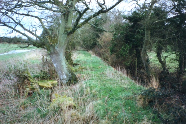
The Pale north of Rathcoffey
The reason the Graiguepottle to Baltracey section survived may be due to the fact that is was used as a road which was in use until the end of the 18th century. This section was the dividing line between the two medieval parishes of Clonshanbo and Balraheen and a continuation in a southerly direction of that parochial boundary shows signs of is a double ditch and high banks which we can assume is a continuation of the Pale.
In medieval times a bog or moorland extended from the southern area of Clonshanbo to parts of Hodgestown and on to Moortown. This area is between the Graiguepottle section of the Pale and the Clongoweswood section and is in the direct line that the Pale boundary would have to extend across. So as there was at the time a natural boundary in this area it was unlikely that a continuous Pale ditch was constructed across the latter townland. However, there was one area of arable land at Painstown which was also between the two previous mentioned sections of the Pale. It appears that Painstown Castle formed another link in the chain of Castles guarding the Pale. There are banks and earth-works in its environs which survived as a section of a road and it is highly likely that this earthwork is also a portion of the Pale. Clongoweswood Castle one and a half miles south of Painstown Castle was strategically sited as it guarded the pass between the lake at Loughbollard and the Moorland at Moortown. The most southerly section of the Clongoweswood Pale ends close to the townland of Loughbollard. The area of land between this section and the Town of Clane was part of an ancient lake and it is unlikely that the Pale was constructed here as it formed a natural boundary. With the river Liffey serving as a natural boundary from Clane upstream to Ballymore Eustace, it is also unlikely that the Pale ditch was constructed through the centre of Country Kildare.
The Bishops and Sheriffs of the four counties were to act as Commissioners with the power to call on the inhabitants of the area through which the Pale was to be built, to assist in its construction. As a reward, their overlords were to grant them fixed rents for one year. Furthermore as long as they or others occupied that land they were responsible for the repair and upkeep of the rampart. Failure to comply would result in a fine of forty shillings. The lands through which the Pale was to be constructed from Kilcock to the Eustace possession at Clongoweswood was held by Sir William Wogan of Rathcoffey. Sir William was appointed High Sheriff of Kildare in 1502 and his duties would have included collecting taxes, arresting criminals and seeing to the defence of the county. Therefore he would had a very important role to pay in defending the Pale boundary in Kildare, particularly the section through his own lands between Kilcock and Rathcoffey. It is almost certain that he was responsible for constructing the Pale in this area. The money raised for these fortifications was also channelled into the strengthening and construction of castles and tower-houses. In some areas the land owners used the money to rebuild and repair castles, this is borne out by the fact that only a few actual lengths of the Pale ditch were constructed as intended while there appears to have been several tower-houses built. As early as 1429 the King offered a £10 grant to subjects who built a tower-house according to his specifications in the four counties later to be referred to as the Pale. Tower-houses subsequently sprang up all along the line of the Pale and two probable examples of these are at Painstown and Richardstown.
Records from 1515 show the Pale running along the same boundary as it did in 1494. However, an inner limit of a Common Law area, where English Law was practiced was defined by Justice Luttrell in 1537 and this indicated the Pale had shrunk to its lowest point to within ten miles of Dublin where St Wolstans and Leixlip marked its western boundary.
The Pale defence system was more than likely intended as an inner line of defence to defend Dublin. It would have been impossible to construct a defence system which included the entire area of the four obedient counties which stretched as far west as Mullingar and as far south as Carlow. This may account for why the Pale extended through the middle of the Wogan and Eustace lands in North Kildare leaving large sections outside the Pale.
While Hadrians wall was a limited success the ‘Pale’ as a defensive system was almost a complete failure. It did not prevent the attacks or cattle raids by the native Irish and many medieval settlements in North Kildare did not survive. Of the five principal villages in the central area of north Kildare, the two inside the Pale, Kilcock and Clane continued in existence, while the three outside the Pale, at Cloncurry, Skullogstown and Mainham eventually declined and disappeared. However, the Pale did provide the launching pad for the Tudor re-conquest of the country in the 16th century. After the fall of the house of Kildare and the re-conquest of Leinster the term ‘inhabitants of the Pale’ or ‘those inside the Pale’ was used by nobility such as the Aylmer’s of Donadea, the Wogan’s of Rathcoffey and the Eustace’s of Clongoweswood to reflect a superior social order. The nobility living in the four obedient counties regarded themselves as ‘Pale dwellers’ up until the mid 17th century until the coming of Cromwell who showed no distinction between the old English of the Pale and the native Irish who dwelled outside the Pale. However, a class culture where Lords or Gentry of the Pale regarded themselves as superior continued into the modern period and the term ‘outside the Pale’ has persisted to this day as a derogatory term for inhabitants who live outside the greater Dublin area.