Seamus Cullen’s Personal Web Site
Featuring Local History from North Kildare
Know your Townland – Baltracey
Published in Le Chéile May 2013
Baltracey is a townland situated halfway between Kilcock and Clane in north Kildare with a history that extends back to the iron age in the period before the coming of Christianity. The placename come from the Irish Baile Trasna, the place of the crossing. In the early Christian period an ancient road extended across townland and in doing so crossed the Baltracey River. This crossing gave the townland its name.
The Slighe Mór
The ancient road in question was Slighe Mór which was one of the five great roads that extended from Tara. This road proceeded from Dublin Bay before crossing the country to Galway Bay. On its course the road extended on high ground or on an elevated ridge. It proceeded on high ground from Ladychapel to Baltracey and after crossing Baltracey River it continued eastwards on a continuation of the high ground to Donadea. A ring fort marks the northern bank of the stream where it crossed at Baltracey and this may have had a link to the road either as the ford keepers residence or a house of hospitality.1 Very little remains of the over ground archaeology of the ring fort at Baltracey, however, a circular shaped feature in the landscape of approximately 45 meters in diameter is identifiable.
Norman Baltracey
Evidence of Norman occupation also survive in the landscape and this is verified by an aerial photo taken by Cambridge University in the 1960s. One of the features show a rectangular shaped Norman farmstead usually referred to as a moated site in an area close to the ring-fort. Unfortunately this has not survived to the present time.
Anastasia Wogan’s Dower
In the early 14th century the townland passed to the Wogan family of Rathcoffey Castle. A document relating to a Wogan family settlement in 1417 gives the first mention of Baltracey. The surnames of many of the tenants living in the townland such as Tyrrell, Barrett, Roche and Rochford are still present in the general area. They held small holdings of between one and a half acres and fifteen acres, however, the average sized holding was two and a half acres. The rent they paid to the Lord of the Manor worked out at one shilling per acre. The document also showed there was a wood dividing Baltracey with a neighbouring townland.2
Civil Survey
A division of Wogan property in the late 15th century resulted in the ownership of Baltracey passing to the Eustace family. In 1640 the townland then known as Baltrasny was held by Maurice Eustace of Castlemartin near Kilcullen. The estimated area of the townland was 158 acres. Although, there is in excess of 700 statute acres in the townland today, the 17th century measurement was an estimated figure by a different measure. It was divided as follows: 140 acres described as arable, 10 as pasture and 8 acres as shrubbywood. The value of the lands as they were let or worth to be let in 1640 was £63. The townland suffered as a result of the wars of the 1640s and by 1654 the only substantial building was a corn mill which was describes as waste.3 This mill was sited close to the ancient crossing of the Baltracey River at a small bend in the river approximately 300 yards east of Baltracey Bridge. The Eustace family lost possession of the townland for a short time during the Cromwellian period but regained the ownership in the early 1660s. A census taken during this period in 1659 indicated that the townland had a population of 41 persons. This compares with a population of 37 in the 1901 census almost three and a half centuries later.4
Sir William Fownes
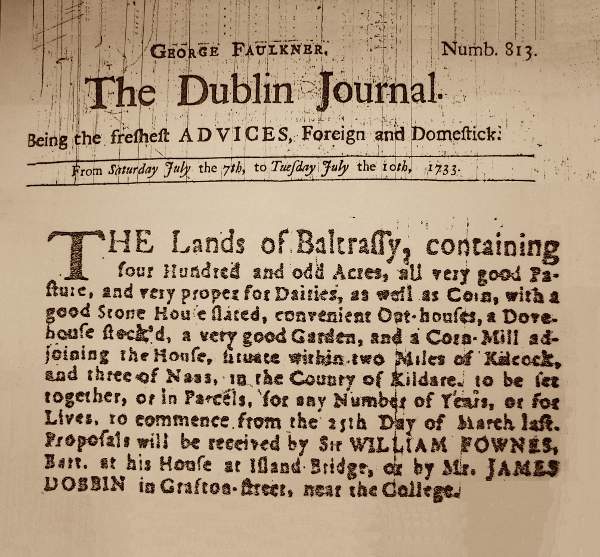
Newspaper advertisement publicising the sale of Baltracey in 1733
In 1707, the Eustace family ownership in Baltracey came to an end when Margaret Eustace sold her interest in the townland to a Dublin nobleman named Sir William Fownes.5 The year following his purchase he served as Lord Mayor of Dublin. He made many improvements to the estate, laying out orchards and plantations, building dwelling houses and possibly the original Baltracey House, a stone-walled slated farmhouse situated a quarter of a mile north-east of Baltracey Cross on an old road system. Beside this house was a farmyard consisting of barns, stables and a pigeon house. In about 1730 Fownes built a new corn-mill on the Baltracey River.6 It was probably built on or close to the site of a previous mill mentioned in the Civil Survey of 1654. This mill was sited some 70 meters from the bend in the river (the original crossing mentioned earlier). It was supplied with water by way of a channel extending from the bend in the river to the mill.
Quaker community
In 1734 Fownes sold his interest in the townland to Caleb Eves who was a member of the Quaker community from Edenderry. This was the beginning of an important Quaker connection with the townland. It is likely the corn mill would have been one of the main attractions of this estate to the Quakers and for three generations they successfully managed the estate and operated the corn-mill. The small community consisted of three families named Eves, Watson and Doyle who were closely related.
A rerouting of roads system in about 1790 resulted in the emergence of the present road system. The more ancient roads that had serviced Baltracey since the medieval period had extended in an east west direction from Balraheen Church to the church at Clonshanbo. One of the new roads extended from a north south direction linking Kilcock and Clane. A second road proceeded in an east west direction linking the townland with Maynooth and Donadea. The new crossing in the townland where the modern roads met became Baltracey Cross. A small section of the ancient road survives as part of the new road extending from Baltracey Cross to Balraheen.
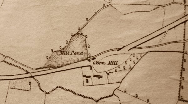
Map showing Baltracey Corn Mill pond in 1837
Following this rerouting of roads the Quaker families moved their residential centre from the area serviced by the old roads to the Maynooth Road where the new Baltracey House was built. The Corn Mill was relocated also to the Maynooth Road where a substantial mill pond extending to one and a half acres was constructed to provide a ready supply of water to harness the water mill.
1790s Revolutionary Period
The Quakers were pacifists and there were tensions within the community during the difficult and rebellious period of the 1790s due to considerable Defender activity in the general area. The house of Mark Eves in Baltracey was attacked which resulted in considerable damage to his property. During the attack Eves threatened to shoot his attackers and this was contrary to the laws of his religion. He was subsequently investigated by his religious elders but no action was taken. His neighbour Peter Doyle was not so lucky and was expelled from the Quaker religion for expressing his intentions of using firearms if necessary to protect himself and his property.7
By the second decade of the 1800s the community had declined with only two Quakers living in the townland. The death of Nancy Watson in 1926 brought an end of over 90 years of Quaker residency in Baltracey. The Quaker families in the townland had belonged to the Timahoe meeting area and their descendents continued to hold the freehold of the townland until the ‘Windham Land Act’ of 1903.
- For details of the Slighe Mór, see Hermann Geissel, Road on the Long Ridge (Newbridge, 2006).
- Matthew Devitt, Dame Anastasia Wogan’s Dower, in Journal of the Kildare Archaeological Society, Vol III, pp 89, 92.
- Robert Simington, The Civil Survey AD 1654–56 Vol. VIII, County Kildare (Dublin, 1952) p. 209.
- Seamus Pender, Census of Ireland 1659, p. 406.
- Registry of Deeds, Book 18, Page 22, Memorial 9579.
- Registry of Deeds, Book 79, Page 160, Memorial 5517.
- Glynn Douglas, Friends and 1798 (Dublin, 1998), p. 32.