Seamus Cullen’s Personal Web Site
Featuring Local History from North Kildare
Know your Townland – Millicent
Published in Le Chéile; Part 1 in October 2013 and Part 2 in November 2013
Millicent is a well known townland located almost half way between Clane and Sallins. It is situated in a picturesque setting with the river Liffey forming the boundary almost in a semi-circular direction in the south and south-east section of the townland. One of the reasons that the townland is well-known is due to the presence of the architectural renowned Church of St. Michael and All Angles. However, this building is a comparatively recent constructions dating from the 19th century, but the known history of the townland goes back beyond that period for several centuries. Throughout history it had connections with many well-known individuals and also a slight connection with King Brien Boru and King James II. The original name of the townland was Newtown which was often referred to in records as Newtown de Clane. It is likely to have obtained this name in the early medieval period possibly due to a movement to the townland of residents from the medieval settlement of Clane.
Medieval Period
An early reference to Newtown dates from 1395 and relates to a dispute concerning tenements in a number townlands in the area of Clane. Another documentary source from 1533, names an individual by the name of Walter Dale as having a small income from Newtown of Clane. It is known that the Franciscans from the Abbey in Clane were granted property in Newtown of Clane and following the dissolution of the Abbey by Henry VIII, the property was granted to Robert Eustace and Thomas Luttrell in 1542. An interesting grant of lands in Newtown de Clane to Thomas Challoner from 1587 includes a grant of an ‘Ash Grove’. This indicates that there was an important and valuable plantation of Ash trees in the townland. At the time Edmund Eustace was the freeholder of the lands.1
Civil Survey
The Eustace family retained the ownership of the townland into the 17th century. According to the Civil Survey of 1654 the townland of Newtown was held by Christopher Eustace who lived at Newlands, close to Twomilehouse. The estimated area of the townland was 263 acres of Irish plantation measure. This was divided into 150 acres of arable land, 103 acres of meadow and 10 acres described as pasture heath. The value of the land as they were let or said to be let in the year 1640 was put at £36 4s.2 However it did not include all of the present townland, as an area the southern portion of Millicent today was in a separate townland named Horestown.3 At the time the northern and part of the western boundary of the townland was marked by a highway called Crostany.4 It is likely this highway extended westwards from Clane to Caragh and was named after the ancient townland of Crostany which was situated today in an area of Firmount West.5 There were two structures of note on the lands of Newtown, firstly a Castle with a Hall adjoining. The site of this castle according to the Down survey map was in the area of Millicent house. The second structure in the townland consisted of a corn mill which in the year 1640 had a letting value of £5 per annum.6
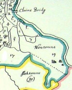
Petty’s Down Survey Map, 1654
In 1659, Newtown of Clane had a population of 43, in which four individuals were described as English. There was one member of the gentry named Humphrey Mills living in the townland.7 It is likely he was one of the many English born Cromwellian supporters that were granted land under the Cromwellian plantation. With the restoration of the monarchy most of the previous owners regained their estates. For a short period in the late 17th century the townland passed to James Duke of York later James II. His ownership ended with his abdication and flight from Ireland in 1690.
In the early years of the 18th century the townland passed to Colonel Robert Harmon a military officer from county Carlow.8 A gravestone erected by Colonel Harman survives today in the ‘Old Church’ yard of Clane now the cemetery in the grounds of the Abbey Community Centre. It commemorates the memory of his faithful servant and soldier, John Hitchcock, who was born in England, and died in 1743.
Name changed to Millicent
It was during the ownership of Colonel Harman that the name of the townland was changed. Documents show that by 1755 the townland was known as Millicent. According to Archdeacon Sherlock the origin of the place name Millicent is unclear, although it is believed that it may well be connected with an the ancient name of a corn mill known as Mullina-fooky. The ancient corn mill was situated at Millicent Bridge and the name comes from Poka or Pucks Mill. The Irish name Púca referrers to fairies. According to the Manders family who lived in nearby Castlesize the local folklore tradition regarding the corn mill was that a good natured Puck or Phouca used to grind corn left there overnight.9
MPs from Millicent
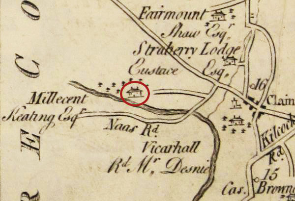
Taylor and Skinners Map, 1777
In 1728, following his retirement from the army, Colonel Harman served as High Sheriff of county Kildare. He was elected to Parliament in a by-election for the Borough of Kildare in 1755 and served this constituency in the Irish Parliament in College Green, Dublin until the election of 1761. By that time he had moved to county Longford where he had inherited property. He continued his parliamentary career in that county until his death without issue in 1765.10 The oldest part of Millicent House dates from the ownership of Robert Harman and it is clearly marked as a substantial house on Noble and Keenan’s Map of 1752. Other subsequent owners also left their imprint on the house and evidence of this is well documented.
For a short period in the 1750s Robert Harman let Millicent house to Sir Edward O’Brien of Dromoland Castle. Sir Edward was a direct descendent of King Brien Boru and he used the house a residence while engaging in his leisurely pursuits in Dublin and Kildare.11 Following the death of Robert Harmon, the ownership of Millicent passed to a close relative Rev Cutts Harman, Dean of Waterford. In 1768 he sold the leasehold to Michael Keating who was originally from county Tipperary. Six years earlier in 1762 Keating had married Marie Burgh from Berth near Athy and moved to the county. In 1777 he was elected to Parliament in a by-election for the Borough of Harristown. The following year in 1778 he served as High Sheriff of county Kildare. He held the seat in Parliament until his death in 1781.12
Griffith family
The next prominent figure to reside in the townland was Richard Griffith who purchased the townland in 1782. He had been a successful trader for the East India Company and also made a fortune trading on his own behalf.13 Like the two previous owners of the townland he also served in Parliament. In 1783 he was elected an MP for a Borough in Limerick and remained in Parliament until 1790. He served as High Sheriff in 1788, also continuing a tradition of his predecessors in Millicent. Regarded as a liberal landowner he was friendly with and socialized with local United Irishmen such as Archibald Rowan, Wolfe Tone and Wogan Browne. His role in the local 1798 rebellion as a Yeoman Captain is well known. Although he fought gallantly against the rebels in Clane during the rising his legacy has been blighted due to his role in the arrest, trial and execution of his neighbor Dr. Esmond.seven hundred sheep from the farm at Millicent were taken by the rebels, obviously to feed the rebel army in their camp. Griffith, nevertheless, obtained generous compensation from the Government. However, luck seems to have deserted him in the years following the rebellion. He lost his fortune said to be in the region of £90,000 on shares in the Grand Canal and by 1808 had sold Millicent House, probably because of diminishing financial resources.14
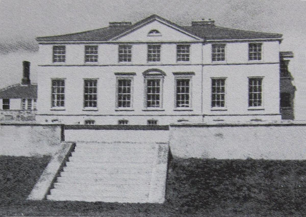
Millicent House
His son Sir Richard Griffith (1784–1878), was to become Ireland’s most distinguished engineer and surveyor. He best remembered for producing a famous geological map of Ireland and his valuation of Ratable Property in Ireland, the Griffith Valuation is a major source of information to genealogists today.15
19th Century Millicent
Many changes occurred in Millicent in the 19th century, the old bridge was demolished and replaced by the present bridge. It was unsuitable for modern traffic at the time due to the fact that the width of roadway across it was narrow and its arches were lofty which gave it an awkward rise in the middle.16 In the mid to late 19th century the possession of Millicent was held by the Cooke-Trench family. The greatest legacy of Thomas Cooke-Trench who died in 1902 was his involvement in the construction of St. Michael and All Angles Church which was built in 1884 on land that he donated for the purpose.
Footnotes
- Thomas Cooke Trench, Correspondence to the Editor, JKAS, Vol. III, p. 131.
- Robert Simmington, The Civil Survey AD 1654–56, Vol. VIII, County Kildare (Dublin, 1952), p. 151.
- Walter FitzGerald, ‘Notes, the Millicent and Firmount townlands’ in JKAS, p. 424.
- Simmington, Civil Survey, p. 151.
- FitzGerald, Millicent, p. 424.
- Simmington, Civil Survey, p. 151.
- Seamus Pender, Census of Ireland, 1659 (Dublin, 1939), p. 398.
- Cooke Trench, Correspondence, p. 131.
- W. Sherlock, ‘Some notes on Fords and Bridges over the River Liffey’ in JKAS, Vol. VI, p. 301.
- Thomas Ulick Saddlier, ‘Kildare Members of Parliament 1559–1800’ in JKAS, Vol. VII, pp 400–401.
- Grania R. O’Brien, These my Family and Forebears – the O’Briens of Dromoland, pp 70–71.
- Saddlier, ‘Kildare Members of Parliament 1559–1800, continued’ in JKAS, Vol. VIII, p. 71.
- Tony McEvoy, ‘Richard Griffith c. 1752–1820’ in Fugitive Warfare (Clane, 1998), p. 106.
- Ibid, pp 106,111.
- Ibid, pp 105,109.
- Sherlock, Fords and Bridges over the River Liffey, p. 301.