Seamus Cullen’s Personal Web Site
Featuring Local History from North Kildare
In search of Clane’s Medieval Leper Hospital
Published in Le Chéile, June 2020
Clane Hospital, established in 1984, is well-known nationally among private hospitals in the country. Before it, Firmount Sanatorium operated as a fever hospital for much of the 20th century and was considered to have been Clane’s first hospital. However, this is not the case. Preceding both, Clane actually had a leper hospital, which dates from the medieval period. Its exact location has baffled antiquarians and historians alike. Recently, however, an examination of ancient leases has narrowed down the possible site to a more specific location.
Leprosy was a common disease from the early-Christian period. The ancient lives of St. Bridget record no fewer than ten occasions on which she came into contact with lepers. They came to her monastery in Kildare for cures and Bridget was recorded as having healed people on several occasions.
Following the Norman Invasion of Ireland, settlements were established and evolved into towns. By the 13th century, human contact was understood to spread the leprosy disease and was a problem for people living in close proximity with others.
From the beginning, the Church authorities acted to isolate ‘lepers’. In 1175 the English Church Council ordered that lepers should not live among the healthy. The Lateran Council at Rome in 1179, decreed that leper communities should have their separate priests, churches and cemeteries. People with leprosy were shunned in society through fear of contagion, which was exacerbated by how the bacterial infection disfigured those who were infected. The mysterious disease was also widely represented as a divine punishment for sin.
Quarantine sites for leprosy were usually developed at remote areas on the edge of towns. The standard pattern of buildings within these communities consisted of a cluster of timber-built cottages around a detached chapel. Sometimes, communal infirmaries replicated other medieval hospitals with a chapel at its east end. Residents were prohibited from leaving the hospital environs, and men and women were strictly segregated within the quarantine area. Lands were granted to the various leper hospitals and knowledge of their locations has faded with time, in part due to their isolation from the general population. To identify the sites, historians can pinpoint association through placenames such as Leperstowne (Baile na Lobhar), Lepardstown or Maudlins.
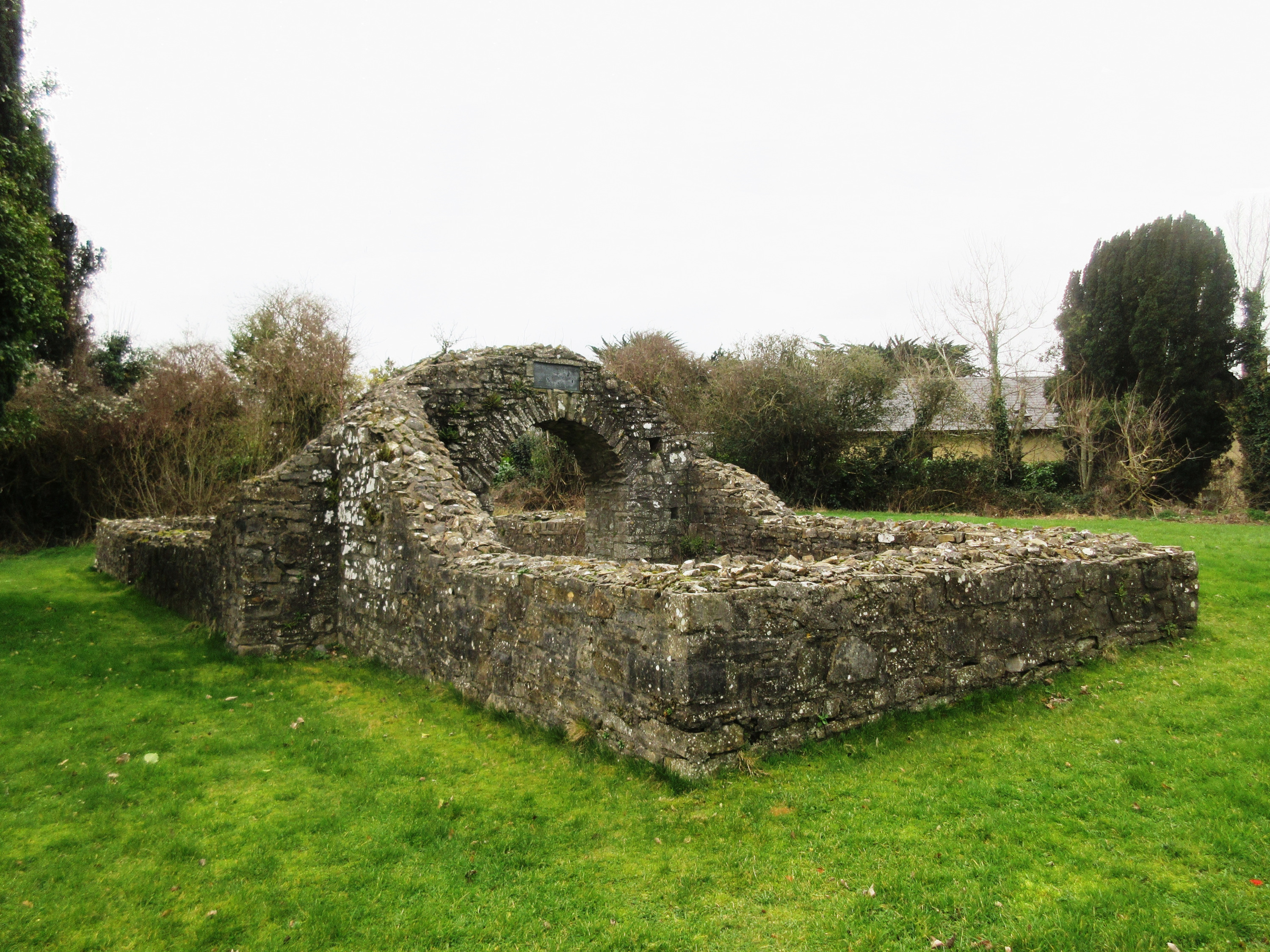
Ruins of the chapel at Trim Leper Hospital.
Place names bearing the name Maudlins or Maudlin are found in many counties adjacent to significant medieval Norman towns such as Trim, Naas and Clane and indicates the existence of a medieval hospital dedicated to St. Mary Magdalene. Unfortunately, in most of the locations no buildings or ruins survive, and the only means of pinpointing the existence of a leper hospital is through the placename. Sometimes placenames alone may not be definitive proof of an actual hospital site, but merely an indication of land donated to a historic leper community.
However, specific references to churches or chapels dedicated to St. Mary Magdalene is a definite indication of the existence of a leper hospital. In medieval Ireland and Britain, the memory of the saint was associated with leper hospitals, and their communities, who were regarded as on the margins of society. Sites, areas and townlands with leper hospitals subsequently evolved to be known as ‘Maudlin’ or ‘Maudlins’.
In addition to the leper hospitals at Clane and Naas, two others were situated in County Kildare at Castledermot and Kildare Town. The latter is recorded in a document dating from 1307, but few other details are available. Dr. Roche MacGeoghegan, bishop of Kildare 1629–1644 compiled a list of churches and chapels in the diocese during his term as bishop. In the parish of Clane, which at the time extended from Betaghstown to Millicent, two churches are recorded, St. Michael’s parish church at Clane (the modern Abbey Community Centre) and the Chapel of St. Mary Magdalene referred to as ‘juxta Clain’ [next to Clane]. The ruined church within the confines of the Franciscan Friary was by then suppressed for almost a century and was not listed.
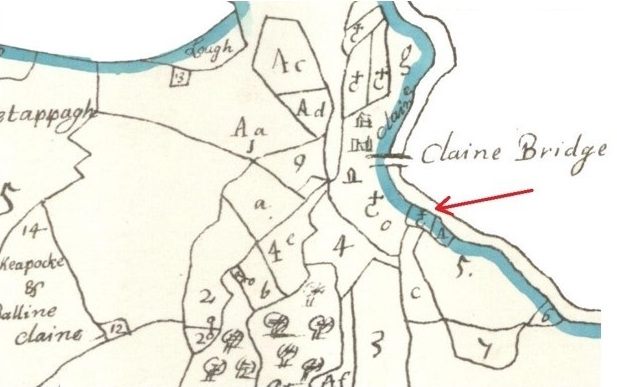
Petty’s Map, 1654–8. The red arrow points to a glebe south of Clane bridge, which is likely to be in Maudlins townland.
The St. Mary Magdalene Chapel at Clane was almost certainly the chapel attached to the medieval leper hospital. It may also have operated as a penal chapel during the 1630s. Despite being ruined for a considerable period, it is possible that the chapel was used by Catholics in the post 1540s following the church reformation. St. Michael’s Parish Church in Clane was taken over by the Crown for the local Protestant community. In the early Stuart period (1603–1640) when anti-Catholic laws were not strictly enforced, a certain toleration permitted Catholics to practice their religion discretely. Catholic Chapels were known to have existed openly in the older Ladychapel site between Rathcoffey and Maynooth, and in a back lane in Kilcock where a Dominican chapel was in use.
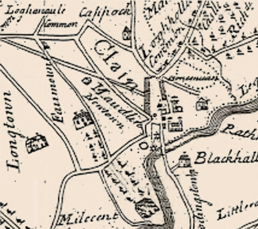
Nobel and Keenans’s Map of 1752.
A townland named Maudlins near Clane remained in existence until the late 18th century. In 1700, Maudlin ‘by Clane Castle’ and also ‘Maudlinstown, near Clane’ is listed in records. Between 1720 and 1771 a townland named ‘Maudlins and Mill’ features in several transactions of leaseholds by Agmondisham Vessy of Lucan one of the principal landowners in Clane at the time. Vessy had acquired the property through his marriage to Charlotte Sarsfield, a niece of the famous Patrick Sarsfield. The townland was described as containing one castle and a mill with an area of 76 acres 1 rood and 32 perches—an Irish plantation measurement which is the equivalent to 124 statute acres. The Mill, commonly known as ‘Sarsfield Mill’, was on the western bank of the Liffey close to the ancient bridge of Clane now Alexandra Bridge. Maudlins featured on Nobel and Keenans’s Map of 1752 which shows the townland in the area between the mill of Clane and the Millicent Road. By 1837, when a form of standardisation of townlands by the Ordnance Survey was carried out. Maudlins as a townland had ceased to exist. Many townlands that featured in 18th century leases did not survive as distinctive listed townlands into the 19th century.
Today the site of Sarsfield’s Mill, later known as McCracken’s Mill, is in the townland of Carrigeens and has an area of almost 98 acres. The adjoining townland Moat Commons has an area of 23 acres. When added, their total area is 121 acres, and almost equals the listed area in the leasehold of Mauldlins. This evidence suggests that the original Maudlins townland was subdivided into the modern townlands of Moat Commons and Carrigeen.
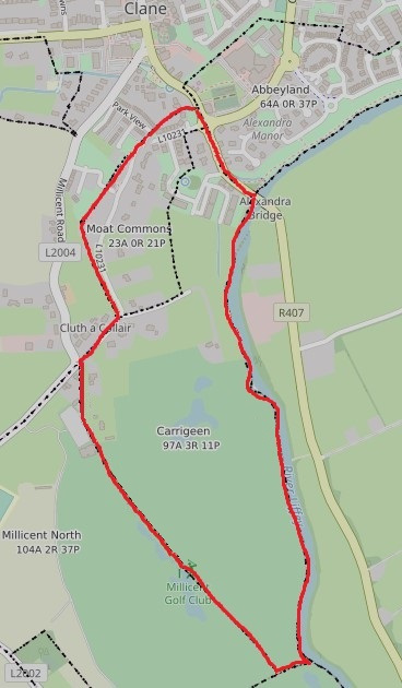
The ancient area of Maudlins is now represented by the townlands of Moat Commons and Carrigeen.
In the late 1990s burials were unexpectedly discovered in the Millicent – Carrigeens area. Writing up the detail in 1999, Hermann Geissel described the chance finding during building excavation work near the River Liffey in the townland of Carrigeen, Clane about 1 km south of the town. The skeletal remains were not enclosed in coffins and were interred at a depth of 60 to 90 cm [24 to 36 inches]. According to Dr Victor Buckley of the Office of Public Works, the orientation of the bodies in an east-west direction would indicate an early Christian burial.
Given that the recent study pinpoints Maudlins townland to this general area, the possibility arises that the burials were linked with the leper hospital. However, it is not possible to determine whether the burials date from the early Christian period, or the Norman period when the leper hospital existed. Updated details from the National Museum of Ireland suggests that there were only two burials. They initially attributed the discovery to being in the Carrigeens townland but are now satisfied that the remains were uncovered in the adjoining townland of Millicent Demesne. The chance discovery was made during excavation work for Millicent golf course in an area close to the Liffey. However, the then boundary between the two townlands has now disappeared within Millicent golf course.
The cemetery of the leper hospital was almost certainly adjacent to the hospital and chapel, and within the confines of Mauldlins townland – possibly closer to Clane than to Millicent Demesne. However, if the Millicent burials date from the Norman period, then further investigation is warranted to establish if the site is associated with the long-lost cemetery of the leper community and hospital in Clane.
The two modern townlands that comprise the original Maudlins are divided by an ancient cul-de-sac road extending from Millicent Road to an area close to the Liffey. This road is clearly shown on early maps leading to a quarry. Although the area is close to the medieval centre of Clane, viz: the castle, mill and Liffey Bridge, access to the location by the cul-de-sac is a much longer circuitous route than a more direct route alongside the Liffey from Clane. The present L10231 road through Moat Commons, via An Crochán, is a shorter route to Clane but does not date from the early period. As previously referred to, Lepper Hospitals were strictly isolated to areas outside the towns. The remoteness of the cul-de-sac, and its connection into the centre of ‘Mauldlins’ may indicate that it was an entrance to the leper hospital.
Another pointer is the existence of glebe land situated at the end of the cul-de-sac. A glebe was an area of land within an ecclesiastical parish used to support a parish priest. Entry to the Carrigeen glebe was from the terminus of the cul-de-sac and consisted of four-and-a-half acres divided into two fields. Sited between the quarry and the Liffey, this glebe is clearly shown on Petty’s map which was compiled between 1654–8 and also the Ordnance Survey six-inch map of Kildare, 1872.
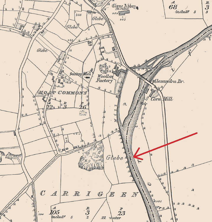
Ordnance Survey Map, 1872. Courtesy of Glucksman Map Library, TCD. The red arrow points to the glebe in Carrigeen.
In 1854 the glebe was let to tenants by Revd. William Caulfield, Rector of Clane. There are many examples of long-lost ecclesiastical foundations located in glebe land where the site continued in church ownership throughout the centuries. At Cloncurry an area of glebe one kilometre south of the ruined medieval church ruins has been suggested as the site of a 14th century Carmelite Friary. Close to Donadea an area of glebe in Clonshanbo with an outline of church ruins within a disused graveyard marks the site of Clonshanbo medieval parish church. The fact that an area of glebe land existed in the centre of the old townland of Mauldlins and a record surviving of a Mary Madeline chapel in Clane in the 17th century, provides further evidence that the long-lost Clane Leper Hospital and chapel may have been located in this general area.
The fact that a leper hospital existed in Clane in the medieval period further points to the influence and significance of the town at the time. The other three towns with leper hospitals in the county are also regarded as significant medieval towns during the period. The leper community of Clane was isolated and shunned throughout the medieval period. In the modern period, their memory has faded among obscured details in historic records to render their location as approximate. It is time for the leper community of medieval Clane to be adequately included in the narratives of local history with the positive recognition that they deserve?
Sources
- Memorial of Deeds of Lease, Maudlins, Clane (Registry of Deeds, Dublin, 76/81/52921; 285/93/185448).
- Michael Comerford, Comerfords Collections, 1885, I, 261.
- Gerard A. Lee, ‘The Leper Hospitals of Leinster’ in JKAS, Vol XIV, No 2 (1966–7), p. 129.
- Aubrey Gwynn and R Neville Hadcock, Medieval religious houses Ireland (London, 1970), p. 354.
- Martin Kelly, ‘A seventeenth century prior of Kilcock’, in JKAS, Vol. XIV, No. 5 (1970), pp 564–7
- Karina Holton, ‘Medieval Cloncurry’ in Ríocht na Midhe, Vol IX, No. 3 (1997), pp 84–5.
- Burials at Millicent Demesne (National Museum of Ireland, IA/20/1999)
- Oughterany, Vol II, (1999), p. 87.
- Michael Potterton, Medieval Trim: History and Archaeology (Dublin, 2005), pp 343–4, 346.