Seamus Cullen’s Personal Web Site
Featuring Local History from North Kildare
Land Transactions in Hodgestown
Published in Path Through the Bog, 2001
Hodgestown is a townland situated in the civil parish of Timahoe and the barony of Clane. It is one of three townlands of that name in county Kildare; the other two are located in the neighbouring barony of Ikeaty and Oughterany.
The townland has an area of 628 statute acres. The earliest known measurement dates from 1654 when it had an estimated area of 170 acres. In 1721 a measurement of 286 Irish acres was recorded and this measurement is equivalent to 464 statute acres. The area at this time did not include a section of bog land situated in the south of the townland. However when Hodgestown was surveyed by the ordnance survey in 1837, it had an area of 628 statute acres and included 109 acres of the Clashbane bog.
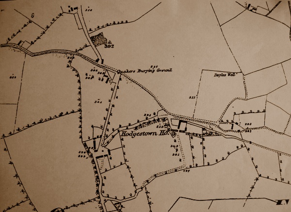
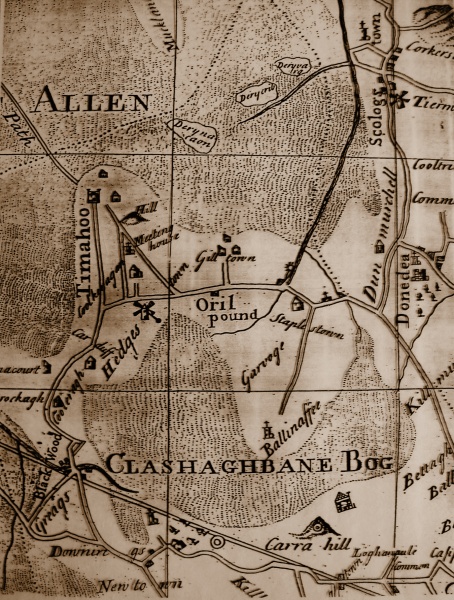
Map showing 19th century estates in Balraheen Parish
The system of land ownership in the seventeenth and eighteenth century was more complicated than the present system. A landowner who often held a number of townlands would lease large units to strong farmers, who would then either farm the entire unit or a section of the land, while letting smaller units to under-tenants. The following paper relates to how this system worked in Hodgestown during the eighteenth century and also the lives of the people who lived there.
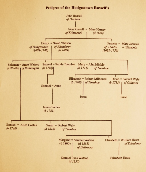
In the early 1700s Joseph Maddock a linen draper from Dublin owned Hodgestown and he was a member of the Society of Friends better known as the Quakers. In his will dated 1717 he bequeathed unto his second eldest son Abraham ‘the townland of Hodgestown in county Kildare which was then in the possession of Henry Russell’. Abraham was to pay his mother Hannah twelve pounds ten shillings every year for the remainder of her life from his Hodgestown income. A renewal of the Hodgestown lease between Abraham and Henry Russell in 1721 gives the first detailed account of the townland. Henrys lease of the townland was a long-term lease and was subject to a total annual rent of £84. This rent was made up of £34 paid half yearly and 6 shillings per acre expenses.
Henry was born in 1678 in Kilmacart county Carlow the eldest son of John and Mary nee Harney and they were members of the Quaker religion. John’s father also named John had moved to Ireland from Durham in his youth. In 1706 Henry married Sarah daughter of Samuel Watson a prominent member of the Edenderry Quakers. Henry and Sarah then settled in Hodgestown where there was already a thriving Quaker community. They had five children, Solomon born in 1707, Samuel in 1710, Elizabeth in 1709, Mary in 1711 and Dinah in 1713. The family was soon linked by relationship to fellow Quakers at Timahoe when Henrys sister in law Ruth Watson married Robert Wyly in 1723. Later that year Robert Wyly and his brother John who lived in nearby Gilltown leased from Henry a plot of land in Hodgestown described as a graveyard or burying place. This burial ground was the Quaker graveyard and it would appear the Wylys leased it in a trustee capacity acting for the general Quaker community. The area of the burial ground amounted to 1.6 statute acres and was described as situated on the road leading from Gilltown to Hodgestown. The lease was renewable and subject to an annual rent of twelve shillings.
Map showing 19th century estates in Balraheen Parish
Two Russell brothers who were relatives of the Hodgestown Russells moved to the area from county Westmeath at this time and intermarried with members of the local Quaker community. Samuel and Jonathan Russell married two Milhouse sisters; Jonathan married Mary in 1730 and Samuel married Sarah the following year. Jonathan however died in 1732 and his widow Mary subsequently married Samuel Greenwood a Dublin merchant.
Henry Russell’s three daughters all married members of the local community also at this time with the marriages talking place in the Meeting house at Hodgestown. Mary married John Mickle from Timahoe in 1731, Elizabeth married Robert Milhouse in 1732 and Dinah married Samuel Wyly from Gilltown in 1744. Henrys second son Samuel married Sarah Chamlee from county Tipperary in 1739. He leased a 160 acre division of land from his father in Hodgestown that was known as Bushfield. This division was situated in the southern part of the townland and was bounded on the east by Gilltown and Garovoge, the west by Corduff, the south by the Clashbane bog and on the north by the rest of the townland. A section of the Clashbane bog was included in this division and it was known as the Bushfield bog. The division was subject to an annual rent of £30 payable half yearly. The lease was witnessed by two local men William Dolan described as a smith from Timahoe and Joseph Mickle also from Timahoe. Later that year Samuel mortgaged his lands to raise £100, he burrowed the money from his uncle Francis Russell a Dublin merchant. Samuel was required to pay Francis £5 interest every year until the loan was repaid. Francis Russell had property interest in East Cooleragh where he held the lease of a division of land from 1729. Samuel Russell however decided to move to Dublin and in 1745 let his land to his brother-in-law Robert Milhouse from Timahoe. The Milhouse’s then moved into Samuel’s house at Bushfield. The annual rent for the land amounted to £45 and the lease was renewable (subject to certain conditions) on the payment of additional charges at the passing of a number of named lives. Samuel went to live in the Coombe area of Dublin and set up in business as a baker. It is likely he had been involved in the milling business in Hodgestown where there was a Windmill that was built on his land at time. However in 1747 he let the Hodgestown windmill to Samuel Greenwood who as already mentioned had links with the Timahoe community. Greenwood who lived in Dublin paid £107 for the windmill, which was described as situated on the land of Bushfield then in the tenancy of Robert Milhouse. The ground where the windmill stood had a passage leading to it from the road and Greenwood was to pay an annual rent of £30 and be reimbursed for any improvements made.
The marriage of Margaret to Samuel Watson
In 1747 Solomon Russell, Henry’s eldest son married Anne Watson from Derrygarron Rathangan. Although Solomon’s mother was a member of the Edenderry Watsons, the Rathangan branch of the family was not closely related. Anne Watson brought to the marriage an annuity of £6 sterling from her father’s estate at Clonsast in county Offaly. Solomon leased from his father a division of land extending to 162 statute acres. This division included the dwelling house and was subject to an annual rent of £30 together with other additional charges. In 1751 Solomon mortgaged his lands for £100 and used the lease as security. Henry Russell died about 1748 and in his will left the remaining 140 acres of Hodgestown jointly to Solomon and Samuel. The will was witnessed by a number of fellow Quaker landowners, his wife’s nephew William Watson and Caleb Eves both from Baltracey and also a near neighbour Benjamin Fayle from Corduff. Solomon and Samuel then partitioned the 140 acre division into two equal 70 acre units. Samuel let his share to Solomon and the exact location of this division was recorded in the transaction. It was bounded on the south partly by the road leading to Gilltown, north and east by the other 70 acre division and on the west by Benjamin Fayle’s farm in Corduff. The right to cut dry and carry away turf out of the Clashbane bog was also included in the lease that was subjected to an annual rent of £12 and other additional charges.
Another major event occurred in the townland in 1751 when Robert Milhouse and his family together with his wife’s brother-in-law Samuel Wyly of Gilltown and his family immigrated to America. The Milhouse’s had relatives in Pennsylvania as Roberts brother Thomas and his family had immigrated to the colony in 1729, and were prospering in a Quaker community which included many from the locality who had already emigrated. Robert and Samuel were offered land in America by Arthur Dobbs who was an extensive landowner in the Timahoe area and had substantial property in South Carolina. Samuel Russell then let Robert’s house and land at Bushfield to his other brother-in-law John Mickle. John however died three years later in 1754 and his Hodgestown property then passed to his brother Aaron who was described as a ‘clothier from Dublin’. In 1769 Aaron sold his financial rights in the lease to Robert Furnas a woollen draper also from Dublin for £750. Furnas then let an 80 acre division of his land in Hodgestown to Samuel Greenwood’s son Benjamin who already held a lease of land in the townland.
The acquiring of leases, there re-sale and use as security for mortgages was normal practice in this period, however the freehold of the townland as pointed out earlier in this paper was held by the Maddock family. In 1749 Abraham Maddock sold the freehold of the townland for £1,700 to George Woods of Dublin. Woods also sold his interest in the townland in 1765 to Richard Cooke also from Dublin for £2,640. This transaction named the tenants as Solomon Russell, Aaron Mickle and their under tenants. A reference to the Windmill was also contained in the memorial. Although maps also accompanied the leases at this time unfortunately no maps appear to have survived. However Hodgestown is marked on two eighteenth century maps together with the road system and major buildings. Noble and Keenans map of 1752 shows the Meeting-house together with two topographical sites Hodgestown hill and the Clashbane bog. It also shows a different road system to the present day roads. A road mentioned in leases leading from Timahoe to the Windmill is indicated as extending west of the Meeting house that was situated within the Quaker burial ground. The road leading from Timahoe to Gilltown extended straight at the bend of the road at the Quaker burial ground and then continued in a south-east direction passing close to Hodgestown house Solomon Russell’s dwelling. Taylors map of 1783 shows the road system had been altered to the present system with Hodgestown house by-passed. As this road alteration was carried out between 1751 and 1783 it was likely that Solomon Russell had a major role in the project.
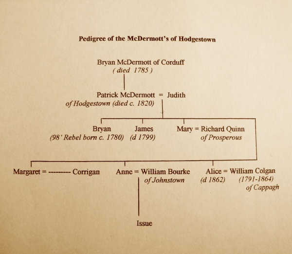
Solomon and his wife Anne had four in family, Samuel the son and heir, Margaret, Elizabeth and Sarah. Sarah married her neighbour Robert Wyly from Timahoe in 1778 and Elizabeth married William Howe from Edenderry the following year. Both marriages took place in the Meeting-house at Hodgestown. The remaining two members of the family Samuel and Margaret were married in 1783 but neither were married in Quaker ceremonies. Samuel married Alice Coates a member of the well known Coates family from Staplestown and Knockanally. The Coates were members of the Established Church and it appears the couple were married according to the rites of that Church as it is recorded in literature from that period that they were married by a clergyman. Margaret married her second cousin Samuel Watson from Baltracey and his family at that time were not practicing Quakers and a clergyman also performed this marriage. The Watsons then took up residence in Balfeighin house, which is situated one mile north of Kilcock. Samuel and Alice who did not appear to have any issue, decided following their marriage and the death of Samuel’s father Solomon in the early 1780’s to let their lands at Hodgestown and move residence. In 1784 they let the estate to Patrick McDermott a prominent local farmer from Corduff. The estate was in three divisions, the first division consisted of 162 statute acres and included Hodgestown house that had been the Russell family residence for almost 80 years. The second and third divisions consisted of a 70 acre and a 65 acre division, brining the total acreage to 297 acres. The rights to the Clashbane bog was also included with the lesser having the right to cut dry and carry away turf. The annual rent amounted to £183 sterling and in addition £13-3-0 other expenses. There was a number of named parties to this agreement, on the Russell side Samuel his wife Alice and also Elizabeth Howe; on the Mc Dermott side Patrick and his eldest son and heir Bryan. The lease was witnessed by Samuel Watson.
The McDermott’s were extensive farmers in the Timahoe area at the time. Patrick’s father Bryan senior farmed 217 acres at Corduff that he had acquired from the Fayle family. In 1785 Patrick leased 84 acres in West Cooleragh from Benjamin Fayle’s sister Mary Bewley, this brought the total amount of land held by Patrick McDermott to 599 acres. The McDermott’s moved into Hodgestown house and successfully farmed the estate. In 1797 Patrick’s eldest son Bryan joined the United Irishmen. It is generally accepted that he was active with the rebels at Prosperous despite his later denial. It may have been due to his influence and knowledge of the topography of the area that the rebel camp was sited in the Timahoe area partly on Hodgestown hill. Following the rebel surrender Bryan was imprisoned until 1802 and on his release, he had to leave the country under the terms of the banishment act. It appears he forfeited the succession rights to his father’s property because of his involvement in the rebellion. As Patrick’s second son James had died in 1799 his four daughters then became co-heiress to his estate.
The McDermot Family Tree
In 1807 Patrick bequeathed 73 acres to his daughter Mary and her husband Richard Quinn from Prosperous. Three years later Anne another of the McDermott sisters married William Bourke from Johnstown. Patrick then conveyed to the couple 227 acres which included the family residence Hodgestown house, a 65 acre division of land known by the name Aughnaculliagh and important bog rights. There were three tenants on this land at this time Thomas Kelly, Richard Connor and Mary Dunne. In 1818 Alice, Patrick’s last unmarried daughter, on her marriage to William Colgan of Cappagh house received the remaining McDermott lands consisting of 65 acres in Hodgestown and 84 acres in West Coolearagh. However there was one notable condition in the agreement, Patrick and Margaret Corrigan the first of his daughters to marry were to receive an income of £40 per annum from this land. An interesting witness to this lease was Gerald Aylmer from Painstown house a brother of William the north Kildare rebel leader.
The McDermott family were paying rents to the Russell family and their heirs who were in turn paying rents to the Cooke family who held the freehold of the townland. In 1820 the Russell interest in the lease was held by a number of parties, firstly, James F. Russell from Dublin a grandson of Samuel Russell the elder, secondly, Elizabeth Howe from Edenderry daughter of Samuel Russell, and Samuel Eves Watson from Larchill the son of Margaret Russell. Patrick McDermott almost 90 years old at this time renewed the lease. He died shortly after this time as his name disappeared from records and this brought to an end the period of substantial landowners in Hodgestown.
- Robert C. Simington, Civil Survey 1654–56, vol. viii County Kildare, (Dublin 1952) p 161.
- Registry. of Deeds.(R D), Book No 17, p. 318, Memorial No. 9190.
- Ibid.
- R D Bk. 32, p. 405, Mem. 20152.
- Quaker library (Q.L.) Lists of Quaker family pedigrees.
- Q L Register of Edenderry records.
- Q L Register of Dublin records.
- Burkes Irish Family Records, 1967 edn, p. 1191.
- R D Bk. 39, p. 190, Mem. 25098.
- Q L Lists of Dublin Records.
- Ibid.
- R D Bk. 107, p. 190, Mem. 73752.
- Ibid.
- R D Bk. 107, p. 439, Mem. 74845.
- R D Bk. 62, p. 262, Mem. 42793.
- R D Bk. 121, p. 518, Mem. 83815.
- R D Bk. 129, p. 492, Mem. 87955.
- Q L Register of Edenderry Records.
- R D Bk. 302, p. 491, Mem. 201067 also Bk. 361, p. 227, Mem. 242734.
- R D Bk. 149, p. 195, Mem. 99437.
- R D Bk. 149, p. 252, Mem. 99637.
- R D Bk. 150, p. 122, Mem. 100344.
- R D Bk. 148, p. 122, Mem. 100345.
- R D Bk. 149, p. 431, Mem. 100347.
- Martin J. Kelly, An Adventurous Timahoe Landlord, in Oughterany Vol. 1, Bk. 2, p. 55.
- Personal communication with Betty Collins (a descendant of the Milhouse family)in 1999. Thomas Milhous was the ancestor of President Nixon.
- Martin Kelly, An Adventurous Timahoe Landlord, pp 55–6.
- R D Bk. 145, p. 379, Mem. 98872.
- R D Bk. 276, p. 196, Mem. 177039.
- R D Bk. 278, p. 314, Mem. 178441.
- R D Bk. 134, p. 370, Mem. 91345.
- R D Bk. 240, p. 620, Mem. 159484.
- Noble and Keenan, Map of County Kildare 1752.
- Alexander Taylor, Map of County Kildare 1783.
- Q L Registry of Dublin Records.
- Seamus Cullen, Baltracey Quakers in Oughterany Vol. 2, Bk. 1, p. 73.
- R D Bk. 361, p. 227, Mem. 242734.
- According to the Index of Prerogative of Wills of Ireland, Bryan McDermott died in Corduff in 1785. For details of the McDermott’s lease of Corduff see R. D. Bk. 410, p. 92, Mem. 267539.
- R D Bk. 376, p. 127, Mem. 250013.
- Liam Chambers, Rebellion in Kildare 1790-1803, (Dublin 1998), p 73.
- Ibid.
- NAI S.P.P. 756.
- R D Year 1834, Bk. 17, Mem. 198.
- R D Bk. 634, p. 401, Mem. 436460.
- R D Bk. 748, p.572, Mem. 509307.
- R D Bk. 751, p. 238, Mem. 510773. In 1826 Revd. Richard Cook sold the freehold of Hodgestown for £1845 to John Maunsell who had an address at Portarlington but later resided at Oakley Park Celbridge.
- R D Bk. 751 p. 238, Mem. 510773.