Seamus Cullen’s Personal Web Site
Featuring Local History from North Kildare
Know your Townland – Moortown
Published in Le Chéile, October 2014
Moortown is a townland adjoining Rathcoffey and was once part of a pre-historic lake that formed a substantial area of the local landscape. The shoreline of the lake is easily recognisable in certain areas of the perimeter of the townland and old placenames in the locality also point to the existence of the lake.
Drummon Rd
The Drummin road is an ancient name for the northern area of Moortown. It extends from Moortown junction close to the Old Rathcoffey Hall to Painstown Cross-roads. The name comes from the Irish Druimín or Dromainn which means a small ridge. The road extends across two small hillocks, which are not easily identifiable in the landscape. The two hills were formed naturally on the shore of the ancient lake in the northern portion of Moortown. In the early medieval period this ridge began to be used as a route-way, and eventually a road was constructed along the route that linked Rathcoffey with Donadea. It is noticeable that the land drops off sharply on either side of the road. The road is therefore elevated and at various points is approximately two to three meters above the surround landscape.1
The Placename
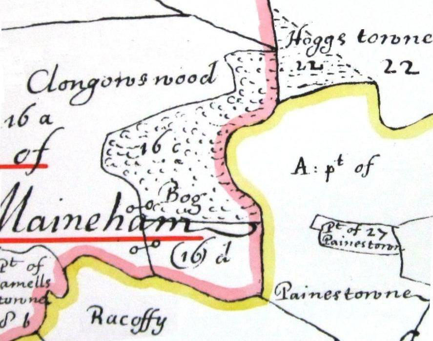
Petty’s Down Survey Map, 1654
Many of the pre-historic lakes that dotted the landscape in ancient Ireland had disappeared by the Early Christian period and were replaced usually by bogs and moorland. The lake at Moortown never developed into bogland, instead it developed into an area of moorland extending from between the southern slops of Rathcoffey Hill to Boherhole and Hodgestown. The townland obtained its name from this source. Many areas of moorland were drained in the period before the ‘Black Death of 1348’ and it is likely an early attempt at drainage in Moortown dates from this time. In 1494 the Pale was constructed in the vicinity of Clongowes Wood Castle and an area north of Rathcoffey. Its purpose was to act a defensive boundary. Moortown lies between the two sections of the Pale, however, no portion of the boundary was built through Moortown as the townland at the time consisted of moorland which acted as a natural boundary.2
Wogan Ownership
The first mention of Moortown in documentary records dates from 1417 and relates to a legal document concerning the Wogan family who owned the townland. It showed that at the time a considerable area of Moortown had been drained and was arable land. Three individuals John Wisse, John Cam and Philip Orewy were listed as tenants in the townland. They rented small holdings ranging from two acres to 19 acres and paid one shilling per acre rent to the Lord of the Manor.3
The townland passed from the Wogans to the Eustace family following a partition of Wogan property in the 1460 period. The entire Manor of Mainham which included the townland Moortown passed to Anne Wogan who had married a member of the Eustace family. She in turn transferred the property to her son Edward Eustace who established his seat at Clongowes Wood.4
Civil Survey
The Down survey map from 1654 clearly shows a substantial area of moorland where much of Moortown situated is today. The area of moorland extended westwards to include a wide area from the south of Rathcoffey, through Moortown and eventually extending to Hodgestown a neighbouring townland. The eastern portion of the townland which was an area close to Rathcoffey Hill was marked as arable land.5 It represented the portion of Moortown that had already been drained and had featured in the Wogan document of 1417.
Stephen Browne Drainage

Taylors Map, 1783
The townland passed from the ownership of the Eustace family following the Confederate Wars of the 1640s. The entire estate of Clongowes which included the townland of Moortown passed to Richard Reynell who in 1667 sold his interest to the Browne family of Jigginstown. In the following century Stephen Browne made improvements to Moortown and a record survives indicating that he was responsible for draining the last section of the townland in the 1720s.6 A stream extending from Loughtown Wood provided for much of the drainage of Moortown at this time. Stephen Browne’s heirs the Wogan-Brownes held the freehold of the townland until the land acts of the late 19th century.
New Road 1780s
With the drainage of Moortown fully complete, a new road was built through the townland in the 1780 period. It extended in a north east direction and linked Maynooth the seat of the Duke of Leinster the premier peer in the country with Prosperous the newest settlement in the county. Prosperous for a time in the early 1780s had become the largest urban area in Kildare. The section of this road that extends through Moortown is known as ‘The Long Road’.7 It was given this name due to the long straight appearance of the road between Moortown junction and Boherhole cross.
Following the drainage of the area and the construction of the new road, the townland underwent an extensive sub-division by the freeholder into several small tenancies. This resulted in the emergence of at least 35 tenancies in which only a handful were of medium sized farms.8
Fr. Kearney
In the early 19th century one of the larger holdings in the townland was let by the Wogan Browne family to Fr. Maurice Kearney who served as Parish Priest of Clane between 1824 and 1842. Fr. Kearney took up residence in the farmhouse on the land which became his parochial house. It was a two story thatched dwelling and was referred to on different occasions as ‘Snipe Lodge’ and ‘Clauber Hall’. In addition to carrying out his parochial duties he engaged in cattle dealing which boosted his income and provided him with additional cash for parochial projects.9 The original entrance into this residence was from the Kilcock to Clane road. When the ‘Long Road’ was built across the avenue, a new entrance was established. However, it was not until Fr. Kearney’s residency that new gate piers at the entrance were built. According to local tradition this was to facilitate a visitation by the bishop. The gate piers remained in existence until the mid 20th century and were known locally as ‘The Bishops Piers’.10 Fr. Kearney died in his residence at Moortown in 1842. During his lifetime he had amassed substantial wealth that amounted to almost £10,000 and shortly before he died with his health deteriorating he made his last will and testament. This will became one of the most important wills of a Catholic clergyman in the 19th century with practically the entire estate bequeathed to ecclesiastical use and local charities.11
Conclusion
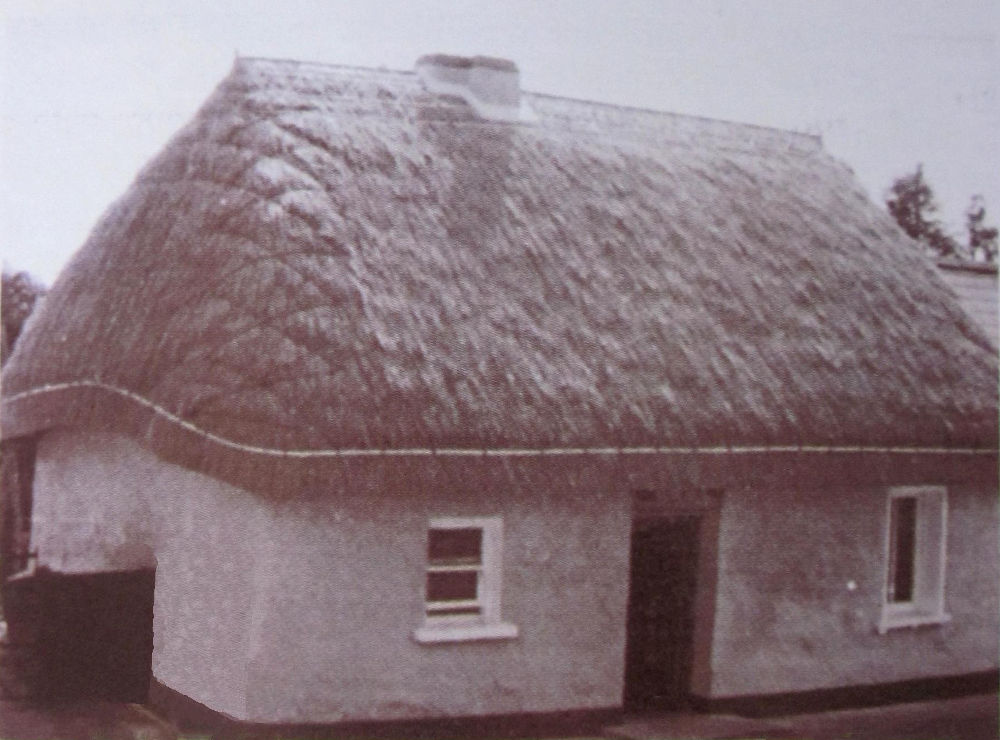
Thatched Shop at Moortown
Although, Moortown is a relatively small townland, with an area of 382 acres it was one of the most densely populated districts in the 19th century. In 1901 it was one of the few rural townlands in county Kildare with an area of less than 400 acres that had a population exceeding 100 inhabitants. Today it is also densely populated with most of the two roads in the townland now part of the built up area that comprises a portion of Rathcoffey Village. The local GAA community centre and much of the Glenbia complex is in the townland together with Moortown Drive housing estate. The only intact dwelling surviving from the 19th century period is the thatched residence which once served as a local shop successively run by the Higgins, Keeffe and O’Neill families.
Footnotes
- See article entitled The Drummin Road, on this web-site
- Seamus Cullen, ‘The Pale in the Donadea area’, in Oughterany.
- Matthew Devitt, ‘Dame Anastasia Wogan’s Dower’, in Journal of Kildare Archaeological Society, Vol. III, pp 88–97.
- Matthew Devitt, ‘Barony of Okeaty’ in, JKAS, Vol. VIII, pp 480–485.
- Petty’s Down Survey Map 1654.
- According to a lease in the Registry of Deeds, 1828.
- See Map of County Kildare by Lieutenant Alexander Taylor, 1783.
- See Griffith Valuation of 1954.
- Martin Kelly, ‘Clauber Hall’ in JKAS, Vol. XV, p. 16.
- Personal communication with Bernard Campbell, Rathcoffey, 2009.
- Seamus Cullen (ed.) A History of Christianity in Clane and Rathcoffey (Clane, 2011), p. 101.